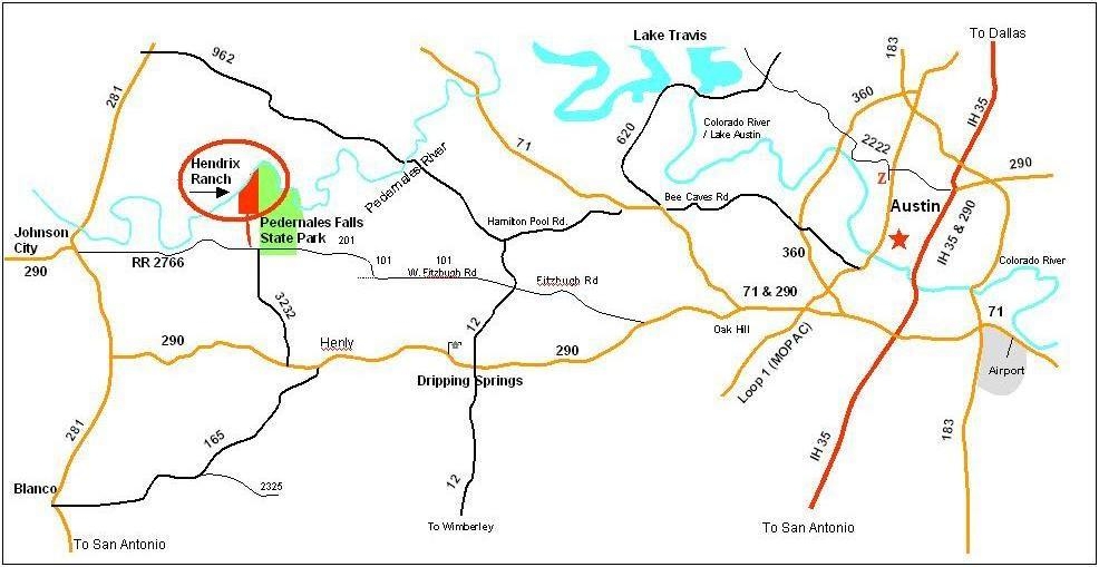
Aug 1 2009 1:12AM
|
Current conditions
Temperature: 75.8 Humidity: 84.2 River Stage: 9.83 (feet) Today's temperatures Rain Data
Data from LCRA station at Pedernales Pedernales Falls State Park
web site |
|
Warnings: (1) The main attraction of the ranch is the Pedernales River. The river water can rise very quickly even on a dry, sunny day if there is rain upstream. If the water starts to rise, move to higher ground immediately. You can climb most of the bluffs. (2) Watch out for rattlesnakes. (3) The ranch is an open range, so watch for cattle as you drive. (4) Unless you know what you are doing, avoid interacting with the cattle, especially the bulls. (5) There are many plants with needles and thorns. MapsAll satelite and aerial images are several years old and may not reflect current canopy coverage or trails.Aerial Road and Trail Map is an aerial map of the ranch that highlights the main roads and trails. Topographic information is also displayed. This is a good map to print out and take with you to the ranch. Hendrix Ranch Map on Google Maps Highway Map is a map depicting the major highways around the ranch and Austin. Directions to the ranchAddress and phone: The official address of the ranch is 8593 Ranch Road 2766, Johnson City, TX 78636. There is a phone at the ranch with number 830-868-2500, but there is almost never anyone there to answer. Cells sometimes work at the ranch. Gary's cell is 512-934-4477. Genie's is 512-934-4480. Google Maps There is a Hendrix Ranch Map on Google Maps. The most southern placemark marks the front gate. To get specific driving directions to the ranch you may select the placemark, and then get directions by clicking the "To here" button and entering in a specific location. Two ways to ranch: There are two ways to get to the ranch from Austin: the "you can't miss it" way, and the short, scenic route. Both routes take about 45 minutes from 360 at Bee Cave Road. |
GeologyThe ranch lies on an interface between two major geologic formations, both of which are limestone and contain fossils. The older formation, located by the river, is tilted and creates waterfalls in the river. The younger one is not tilted and has different, younger fossils in it. There are caves along the interface where skinny people can go spelunking.more info FloraThe vegetation varies dramatically from one part of the ranch to another, reflecting changes in rocks, soils, and drainage. Woody areas covering most of the ranch's land contain lots of cedar and mesquite, but also many oaks of various species, and some ash, madrone, and other trees. In areas not choked with cedar, there is more of an open, park-like oak woodland savannah with prairie grasses and cacti below the trees. A southwestern portion of the ranch has been planted in improved grasses (coastal bermudagrass) and has been historically used as a pasture or field. This portion of the Ranch is fenced off from the rest of the property. Some wetlands lie within this area.more info WildlifeThe Hendrix Ranch hosts a healthy and diverse wildlife community. The proximity of the ranch to other large, open, well-managed properties combined with the diversity of plant life and abundance of water provide the basis for this healthy community. One of main goals of land management at the ranch is further increasing the diversity of wildlife.more info Ranch AttireFor serious ranch exploration and work, durable long pants and boots are recommended as protection against snakes and thorns. There are many plants on the ranch that will try to scratch you or stick you. Close-toed shoes are highly recommended for all ranch visits, and always watch your step very carefully for cacti and other prickly things. Swimming suits are good for actually getting in the water. It is a lot of fun to sit on a rock with your feet in the water. Protection against sun and mosquitos may be warranted in some cases. If you are attending a brush burn, cover your skin and face as much as possible if you want to get close to the fire.Pictures
phendrix at fas.harvard.edu |